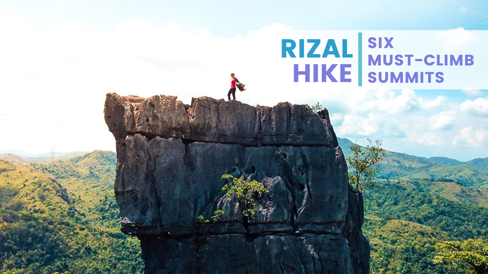
In the past years, hiking’s popularity has risen to greater heights. These days, spending as much time as one can in the mountains has become commonplace. Even most weekend warriors opt to leave the comforts of the city in exchange for a toiling albeit rewarding trek. The province of Rizal has proven to be a favorite among mountaineers. Blessed with a stunning landscape which includes a portion of the Sierra Madre, plus its proximity to the Metro, hikers flock to its folds to scale its seemingly limitless peaks.
So whether you’re a hardcore mountaineer or a beginner, here are five Rizal summits to satisfy your hankering for hikes.
Mt. Tagapo, Binangonan
Found in Talim Island, Mt. Tagapo affords a relatively easy hike. It takes just about two hours to reach its summit, but expert mountaineers can do it in under an hour. Tagapo’s trail starts in Brgy. Janosa, through a rutted dirt path that transitions into a rocky trail. This then passes to a patch of forest before leading into an expansive grassland. The peak looks out into the Laguna Bay and its trademark encroachment.
How to get there:
- There are jeepneys and commuter vans in Starmall Mandaluyong, Megamall, Robinsons Galleria, and Farmer’s Cubao bound for Binangonan.
- Once in the Binangonan town proper, head to Pritil port either via tricycle or walking. From here, take a passenger pump boat and alight at Brgy. Janosa.
Mt. Ngusong Kabayo, Tanay
Mt. Ngusong Kabayo is so named because of the rock formation found on its summit. A limestone outcrop shaped like a horse’s snout crowns this mountain. It requires a bit more stamina to get there, however, as the trail is generally without shade. Passing through thick and tall cogon grass, hikers would be directly exposed to the sun, making the trek more challenging. Nearing the distinct summit, the trail shifts from grass to jagged limestone slabs. This will require careful maneuvering and squeezing through narrow gaps. This will then open up into a panoramic scene of undulating terrain.
How to get there:
- There are jeepneys and commuter vans in Starmall Mandaluyong, Megamall, Robinsons Galleria, and Farmer’s Cubao bound for Tanay.
- In the town proper, head over to the PUV terminal and take a jeepney to Sampaloc.
- Get off at the junction where you can either take a jeepney bound for Cogeo or charter a tricycle. Your destination is Brgy. Laiban. Here, there are motorcycles that will take you to the jump-off.
Alternatively, you may take a jeep or van to Cogeo and alight at Gate 2. From here, walk towards the jeepney terminal where you may get on one bound for Sampaloc. Alight at Brgy. Laiban.
Maysawa Circuit, Tanay
Composed of two mountains: Mt. Sapari and Mt. Binutusan, the Maysawa Circuit is known for its “sea of clouds”. The elusive and much sought-after view often makes an appearance on the summits of these mountains. It takes about 6 hours to complete the circuit, but you may choose to go up just one mountain for half the trekking time. The trail here goes through an upland community before passing through the woods. It then ascends into mostly grassland well unto the peaks, making it conducive to viewing a sea of clouds.
How to get there:
- There are jeepneys and commuter vans in Starmall Mandaluyong, Megamall, Robinsons Galleria, and Farmer’s Cubao bound for Tanay.
- In the town proper, head over to the PUV terminal and take a jeepney to Sampaloc.
- Get off at the junction where you can either take a jeepney bound for Cogeo or charter a tricycle. Your destination is Brgy. Cuyambay. Here, there are motorcycles that will take you to the jump-off.
Alternatively, you may take a jeep or van to Cogeo and alight at Gate 2. From here, walk towards the jeepney terminal where you may get on one bound for Sampaloc. Alight at Brgy. Cuyambay.
Mt. Paliparan, Tanay
Another mountain located in Brgy. Cuyambay in Tanay, Mt. Paliparan used to be a site for illegal charcoal harvesting. A great part of it used to be barren, shrouded in smoke and ash. After community efforts to turn it into a hiking destination, it was able to recover and is now green and thriving. Of all the three mountains in Cuyambay, however, Paliparan is the hardest. With a mostly open trail and sharp ascents, making it torture for the legs. But the many view decks here make it worth it. All affords a 360-view featuring Tanay’s many mountains and all of Cuyambay. A traverse also leads to Sitio Tuoy – a Dumagat community – and to the tiered Tungtong Falls.
How to get there: (See Maysawa Circuit)
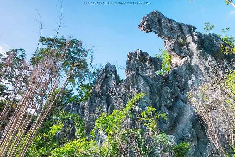
Mt. Masungki and Nagpatong Rock, Tanay
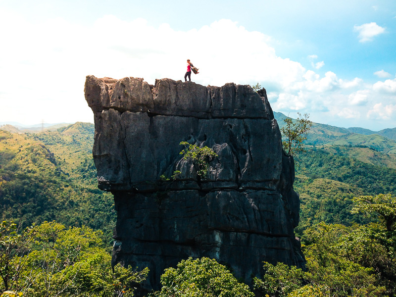
The third of the trio of mountains found in Cuyambay, Mt. Masungki arguably has the most beautiful trail. Mostly forested, the path is flanked with tall hardwoods and is shaded by thick canopies. Limestone outcrops also dot the trail, requiring some rock-climbing. The summit also offers a “surprise” of some sort: a billboard-like structure that’s speculated to be a radar installation. But the highlight of a hike to Mt. Masungki is the sidetrip to the iconic Nagpatong Rock. This limestone butte is oft-photographed and what attracts hikers to Mt. Masungki.
How to get there: (See Maysawa Circuit)


Comments